Sedona Arizona Maps
Sedona Arizona maps are available here to help you get to Sedona. Sedona is easy to reach and well worth the visit. This is the home of Arizona's scenic Red Rock country. It is a relaxed 40 minute drive from Interstate 40 in Flagstaff. Interstate 40 traverses the northern part of the state and connects with Interstate 17 in Flagstaff. Sedona is located in north central Arizona, South of Flagstaff, and at the lower end of Oak Creek Canyon. Sedona is most easily reached by car from Interstate 17. This highway runs from Phoenix in the south, to Flagstaff in the north. The Sedona exit is well marked. To take the scenic route from Flagstaff to Sedona you can use Highway 89A. After transitioning from Interstate 40 to Interstate 17, take the Airport/Fair Grounds exit and turn right... then go about 50 feet and turn left. This route descends into the upper end of Oak Creek Canyon on a somewhat narrow, twisting, two lane highway, and then follows the creek down the canyon to Sedona. This is a beautiful scenic drive.
The Sedona airport is not served by the major airlines. The airport caters primarily to companies offering local tours and to private planes. If traveling by air, I suggest flying into Phoenix and renting a car for the easy, scenic trip to Red Rock country. Get on Interstate 10 , which runs right by the Phoenix Sky Harbor Airport. Then take the well marked I-17 interchange north. Stay on I-17 for about an hour, and get off at the Sedona exit and drive a few miles into town. Once you get to Sedona, a variety of Sedona Arizona maps, Oak Creek Canyon, and West Sedona maps are available free from many merchants and the Chamber of Commerce. The Sedona area has an amazing variety of accommodations for visitors to choose from:
Fine restaurants, art galleries, great shops, cultural activities, and nightlife are also here for you. Do you want sightseeing tours by horseback, jeep, hot air balloon, or helicopter? It's here! Outdoor activities including golf, fishing, biking, hiking, and nature walks attract a number of participants. Some even enjoy rock climbing on the sheer rock walls of Oak Creek Canyon. Several Sedona businesses advertise on this page. If you do not see what you're looking for, you can find it with a Google search using the box below and search phrases such as...
Visit Sedona and be sure to take lots of pictures of your trip.
This is a basic map of the uptown area. I'm presenting it oversize. The size distorts my page layout, but gives you a more readable image.
And here's a map of the West Sedona area...
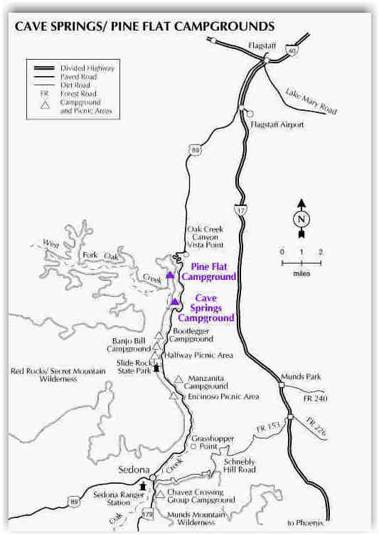
Sedona, as you will see, is an intimate community surrounded by grand scenery. It may be small, but it's certainly not short on amenities. Below is a map of Oak Creek Canyon. There are several good Forest Service campgrounds in the canyon. Most are located right along the creek. Recreational activities in Oak Creek Canyon (including camping) require a Red Rock Pass use permit. Visit the Coconino National Forest's Red Rock District webpages for a lot of good information. Evan if you're staying in town, don't miss the drive through Oak Creek Canyon. It's rated as one of the most beautiful drives in the U.S.
This Sedona Arizona maps page is presented for your convenience and use. Feel free to copy, paste into another program, and print any of the maps shown here. A Google search using the keyword phrase historic map + sedona will lead you to several additional resources. Be sure to notice the relevant ads down the right side... those are resources also.
About This Site Have you read this page lately?
Copyright � 2004-2008 Fred Doyle. All Rights Reserved.
|