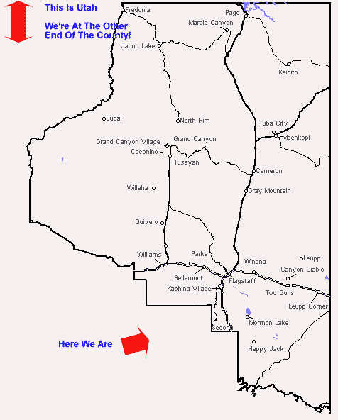
Coconino County Map


coconino county map


The Coconino County map shown below shows the shape of the county and the geographic relationship of many major features.

Coconino County is in north-central Arizona, stretching from the Arizona-Utah border southward to the Mogollon Rim. "The Rim" is a rugged cliff-like escarpment rising one to two thousand feet from semi-desert to the lush plateau that's home to the South of Flagstaff communities. 

Coconino County is diverse in altitude, climate, vegetation,coconino county location map geography, people, and in other ways: 

  • From the bottom of the Grand Canyon to the snow crowned top of the San Francisco Peaks
  • From sparsely vegetated high desert to alpine forests and tundra
  • From Native American tribes to descendants of pioneer families to university students

This is a huge county! Coconino County has a low population (approximately 110,000) for it's size (we like it that way). The county covers 18,608 square miles, and is the largest county in Arizona and the second largest county in the United States in land area.


Indian reservations of the Navajo, Hopi, Paiute, Havasupai and Hualapai People comprise more than a third of the county's land. Thirty two percent is Federal land (Forest Service and Bureau of Land Management). Ten percent is State of Arizona land, and only thirteen percent of the land in the county is privately owned.

Coconino County is home to the Grand Canyon National Park, the San Francisco Peaks, Oak Creek Canyon, Sedona, Sunset Crater and other national monuments, and Lake Powell, in addition to the South of Flagstaff area.


coconino county map


Here is the map of Coconino County Supervisory Districts...


Follow this Coconino County map link for a county highway map with more detail.


SBI! Proof


Coconino County Highway Map

Arizona Maps

Detailed Map of Arizona Page

Sedona Maps

Flagstaff Snow Play Map

Forest Highlands Map

Kachina Village Map

Mountainaire Map

Mormon Lake Map

Pinewood and Munds Park Map

Arizona Congressional Districts Map on the Arizona Representatives Page.


Return To Maps Page

Return to Local News Page

About This South of Flagstaff Arizona Site Have you read this page lately?

Return to the South of Flagstaff Arizona Home Page


coconino county

Copyright © 2004-2010 Fred Doyle. All Rights Reserved
Photo reprint permission granted with conditions
.